

This website uses cookies so that we can provide you with the best user experience possible. Cookie information is stored in your browser and performs functions such as recognising you when you return to our website and helping our team to understand which sections of the website you find most interesting and useful.
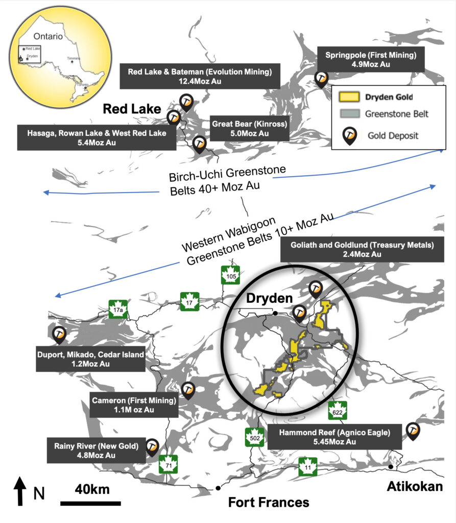
A Prolific Gold Region of Northwestern Ontario


- Over 600 Km2 (60,000 hectares) consolidated by Dryden Gold Corp.
- Excellent infrastructure – Roads, power & labor
- 50 km covering regional gold bearing MDdz structure (Manitou-Dinorwic deformation zone)
- Kinross, Treasury Metals, Kenorland Minerals and Dynasty Gold active in the Dryden Gold District
- Treasury Metals has defined a 3M ounce low-grade resource in the Dryden Gold District
- Limited exploration – only 33,200 meters of historic drilling district-wide at shallow depths
- Initial focus on brownfield opportunity in the Gold Rock Camp
- Recently acquired the fully permitted Cross River property that hosts several cross-cutting east-west structures interpreted to be the source for gold mineralization in this orogenic gold system.
Historical work displays high-grade intercepts across the entire property package and includes:
Gold Rock Camp Drill Intercept Highlights
- Kenwest Patents – 3,497.0 g/t Au over 8.5m
including 53,700 g/t Au over 0.55 meters - Kenwest Patents – 15.4 g/t Au over 6.1m
- 502 Vein – 12.7 g/t over 4.0m
- Canamerica – 12.6 g/t Au over 4.0m
- Cross River Historic Queen Alexandra Mine (0.94 opt)
LOWER MANITOU DRILL INTERCEPT HIGHLIGHTS
- Gaffney – 2.4 g/t Au over 75.1m
- Gaffney – 5.0 g/t Au over 8.8m
- Sherridon – 46.0 g/t Au over 0.5m
TREMBLAY PROJECT DRILL INTERCEPT HIGHLIGHTS
- Turtlepond – 15.0 g/t Au grab sample
- Hyndman – 13.0 g/t Au grab sample
- Avery – 24.56 g/t Au over 2.25 m (channel sample)
- Tabor – 39 g/t Au grab sample
Opportunities in Dryden
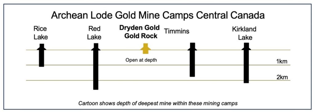
- High grade known to occur in Dryden area
- Limited mining and exploration at depth and geological districts in the area such as Red Lake, Timmins and Rice Lake show
- Minimal geological interpretation to date

Similarities to Dryden
- Similar geology setting with similar rock types and regional folding
- Structural geometry – gold bearing shear corridor with secondary splay structures
- Favourable geological gold traps
Resource Pipeline
Dryden Gold possesses the most extensive land package in the area, comprising numerous distinct targets from conceptual to brownfields. The properties and targets in the pipeline below are consistently being re-evaluated as new technical and field work data becomes available.

Geological Setting – Similarities to Red Lake and Timmins Camp

- Similar geology setting with similar rock types and regional folding
- Near surface high-grade free gold in an Archean setting
- Structural geometry – gold bearing shear corridor with secondary splay structures
- Favorable geological gold traps for high grade shoots
*After 2021 Montsion et. al – simplified geology showing greenstone belt, major deformation zones and secondary structures
Regional Map 1
Regional Map 2

Similar Geology Setting Cartoon
Resource Pipeline
Red Lake and Timmins Camp Similarities