

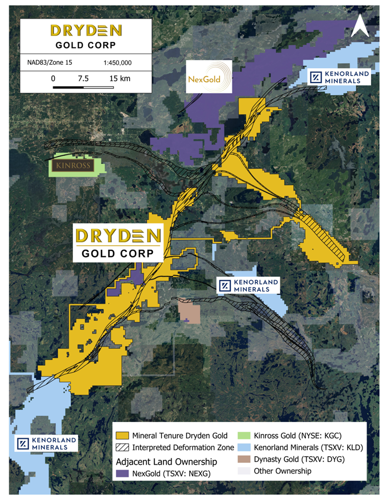
A Prolific Gold Region of Northwestern Ontario


- Over 803 Km2 (80,300 hectares) consolidated by Dryden Gold Corp.
- Excellent infrastructure – including grid power, major highway access (Trans-Canada Highway), and logging roads
- Year round drilling
- High-grade gold across the entire Dryden District
- Limited exploration – only 30,000 meters of historic drilling district-wide at shallow depths
- System has never been tested at depth
- Regional Greenfield targets at Hyndman & Sherridon
- Strategic Investment from Centerra Gold
- Significant tax benefits and government grants
- Collaborative relationships with First Nations communities
Historical work displays high-grade intercepts across the entire property package and includes:
Gold Rock Camp Drill Intercept Highlights
- Kenwest Patents – 3,497.0 g/t Au over 8.5m
including 53,700 g/t Au over 0.55 meters - Kenwest Patents – 15.4 g/t Au over 6.1m
- 502 Vein – 12.7 g/t over 4.0m
- Canamerica – 12.6 g/t Au over 4.0m
- Cross River Historic Queen Alexandra Mine (0.94 opt)
LOWER MANITOU DRILL INTERCEPT HIGHLIGHTS
- Gaffney – 2.4 g/t Au over 75.1m
- Gaffney – 5.0 g/t Au over 8.8m
- Sherridon – 46.0 g/t Au over 0.5m
TREMBLAY PROJECT DRILL INTERCEPT HIGHLIGHTS
- Turtlepond – 15.0 g/t Au grab sample
- Hyndman – 13.0 g/t Au grab sample
- Avery – 24.56 g/t Au over 2.25 m (channel sample)
- Tabor – 39 g/t Au grab sample
Opportunities in Dryden
- High grade known to occur in Dryden area
- Limited mining and exploration at depth and geological districts in the area such as Red Lake, Timmins and Rice Lake show
- Minimal geological interpretation to date

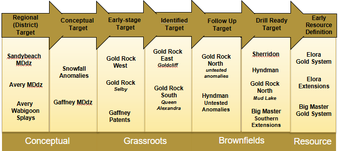
Resource Pipeline
Dryden Gold possesses the most extensive land package in the area, comprising numerous distinct targets from conceptual to brownfields. The properties and targets in the pipeline below are consistently being re-evaluated as new technical and field work data becomes available.
- 2026 Exploration Emphasis on Gold Rock Camp Targets – Growing Gold Rock Target
- Focused on Regional Discovery – First ever drill program at Hyndman Target – New Exploration Targets from Property-wide Soil/Till program
Geological Setting – Similarities to Red Lake and Timmins Camp


- Similar geology setting. rock types and dykes with regional folding
- Structural geometry – gold bearing shear corridor with secondary mineralized splay structures and dykes
- Favorable geological gold traps for high-grade structures
- Near surface high-grade free gold in an Archean setting
*After 2021 Montsion et. al – simplified geology showing greenstone belt, major deformation zones and secondary structures
Regional Map 1
Regional Map 2
Similar Geology Setting Cartoon

Resource Pipeline

Red Lake and Timmins Camp Similarities


